For being the title feature of this blog, you would think that Sand Creek would be a regular feature here. As it is, I have rarely mentioned or photographed this water, this connection to the St. Croix and Mississippi and Gulf of Mexico. Why do I not devote more blog space to Sand Creek?
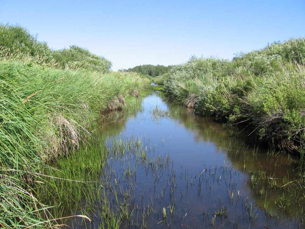
For one thing, as evidenced in the above photo, Sand Creek is not very photogenic. There are no waterfalls, no rapids, no crystal blue shimmering pools. Sand Creek is a ditch. Really. It is still legally considered a county ditch although I know of no agricultural connections to it in the entire watershed. The natural watercourse was straightened in 1918, a time when speculators were trying to entice farmers to the logged-off land here. Straightened creeks are not happy creeks; they yearn to meander freely. Yet Sand Creek adapted better than most, soaking up flow from numerous springs in the area and creating habitat that supported native brook trout within the ditch banks.
Another reason is that Sand Creek is not very accessible. To get to the creek today I walked through the horse pasture, out the back gate, through a tangle of alder and willow with stinging nettle and thistle here and there, up over a steep former railroad crossing, down to the water which is heavily guarded by more alder and willow. I could have walked out to the road, taken a little access driveway on the other side of the creek, walked along the north bank a ways to where low grasses grow up to the stream bank. But I favored the direct route, through the brush.

It was an easy walk as far as streams go; no slippery boulders, very slow current, no deep mucky pools. There was the occasional remains of an old beaver dam, which gave the benefit of diversity; where there was an old dam, the stream narrowed and gained velocity, carving a pool directly below. The substrate was mostly sand, with some crunchy gravel areas which provide good spawning habitat for brook trout. The last time my coworkers shocked this stretch of stream, they found a few adult brookies. Today they were probably in the shady areas along the right side of the picture.
Today's walk, however, was for a deeper reason than mere blog fodder. I wanted to wade the creek, experience it close hand, so I could better try to understand a disturbing trend I've witnessed the last year or two: the water is getting more cloudy. Three years ago, the first spring we lived here, I walked the north creek bank and could look through the water and see brook trout redds (nests) on the gravel bottom of the creek. The water, although brown-colored from tannic acid, which is produced naturally in soft water swamps, was very clear. This year, during spring runoff and a period of base groundwater flow from extreme drought, the water has remained distinctly cloudy.

It should not look like this. I should be able to see the bottom here. Somewhere upstream, sediment is washing into the creek. Looking at the land ownership and use, I'm guessing that some logging took place in the last two years on private land, and the loggers did not follow Best Management Practices, which would be applied on public land, to avoid impacts to the stream. Or it could have been removal of a large beaver dam, but the effect of that would not have lasted as long as this has been happening. I was noticing the turbidity as early as last year.
This is what it should look like. The Hermit and I took a ride today to a road crossing about a mile upstream, then to one maybe five stream miles upstream. This is the latter; the water is brown, but distinctly clear, much clearer than where Sand Creek flows through our land. So whatever it is that's causing the turbidity is happening a few miles upstream, below the upper road crossing.
I can't let this sit. I am concerned about the effects on the few brook trout that inhabit the stream; they are sight feeders, they need cold, clear water to survive. Excessive sediment in the water will choke their spawning areas, cause water temperatures to rise to lethal levels for trout, and make it difficult for trout to find food.
I work for the very state agency that is responsible for the stewardship of Sand Creek, a designated trout stream. I am going to bring this up to my supervisor tomorrow, although I'm not very optimistic about a prompt response. But I will persist; this is my home watershed, this is a creek that someone has to care about, this is a creek that I care very much about. It deserves better than to be suffocated by bad land management.
16 comments:
Absolutely right. That kind of turbidity your home creek does not need. Best of luck getting to the source!
i didn't realize that cloudy water could harm the fish living in it.
How does sediment in the water increase temperature?
Thank God there are people like you who are passionate about their surroundings. Go Deb!
Go get 'em. There need to be some trout in there so when I finally get up to your neck of the woods for a visit, I can ply the waters with the fly rod.
It is really great that you care, and care enough to do something about it. Hope you'll keep us posted.
Greenman Tim- Thanks. Now the problem is figuring out what recourse is available if the source turns out to be humans, not beavers. I'm really beginning to understand what it's like for the average citizen who might call my office concerned about water quality somewhere. I've been looking into pertinent state statutes and agency web sites for three hours now and, as a resource professional, I'm confused!
dragonfly- Certain species of fish are more tolerant of cloudy water than others; catfish and other bottom feeders are adapted to live in muddy waters like the Mississippi. However, brook trout are highly sensitive to degraded water quality.
LauraHinNJ- The suspended sediment increases the heat absorption of the water; the particles absorb heat more readily than plain water. It's especially a problem if the water is brown in color to begin with.
madcapmum- Taking that passion and translating it into action is a big step for me.
dharma bum- yeah, there are so few streams around here that actually have trout in them, it would be a shame to see this one go downhill. I'm hoping to get a fly rod and try it out some time; it seems the only fish we catch on night crawlers are creek chubs and common shiners.
Good for you! I wish more people cared.
Yes, yes, protect Sand Creek...afterall that water's coming to my Gulf.
Sandy and FC- we all live downstream. And FC, I never thought about the connection, but yes, Sand Creek water eventually becomes your Gulf water. Water connects us all. Amazing.
I did a lot of research today at work, and I pinpointed a couple of likely sources from 2003 aerial photos. Also found some photos taken in 2000 that pretty much confirm my suspicions; the water was clearer then. Now I
gotta convince the boss to have me do some ground truthing. This would really make it feel like my job was worth it, if I could protect just one local resource.
This also makes me think...I probably live in a more extreme headwaters situation than a lot of the bloggers I know here. I am just a few miles from the divide that determines whether water flows through the Great Lakes to the Atlantic, or through the St. Croix and Mississippi drainage to the Gulf. Sand Creek is headwaters. What happens at the headwaters affects everyone, eventually.
The headwaters of Moose Mountain Creek are farther away than I thought - I looked at a watershed map a couple of years ago, and this watershed extends all the way up to the McLean area, almost two hours' drive northwest. But the Moose Mountains are an important recharge area, with numerous intermittent streams arising in them and feeding into Moose Mountain Creek in the spring.
Good luck to you. In my experience, the project that I thought I had waited for, the one that would make my job worthwhile, turned out to be the reason that I quit: it should have made a difference, and it didn't. That was a few years ago, and I still work here and there when I feel like it, but I don't pin any hopes on it. Still, I wish you all the best.
I hope you can get to the bottom of things and also can find a solution.
Would the problem be lessened if the stream were not so straight? I know there's nothing you can do about that, I'm just curious!
Go for it, and good luck. We need every quality stream we have!
Laura- sorry to hear that experience didn't work out for you. I don't know where this will go, but out of the personalities at my office I think I'm best suited to be the "habitat" person. We'll see.
Rurality- Things would definitely be better if the stream were not so straight! I've thought of doing a little restoration work eventually; the original stream meanders show up in aerial photos.
Sue- Someone has to care, and I'm probably in the best position to do something! It's encouraging to note that in the past year, two volunteers along Sand Creek have signed up with the Citizen Stream Monitoring Program run by our state Pollution Control Agency. So someone else apparently cares.
Deb - have you noticed other species besides trout in Sand Creek? I read that there was a massive fish kill back in 1998 (from the Seneca plant in Montgomery) and I'm wondering how the creek has been able recover.
Rob- You must be talking about a different Sand Creek; I'm in east central Minnesota about 90 miles north of St. Paul, and fortunately there are no big processing plants upstream! But if you're interested in finding out more about Sand Creek by Montgomery, the DNR fisheries office in Waterville should be able to help you out.
Post a Comment