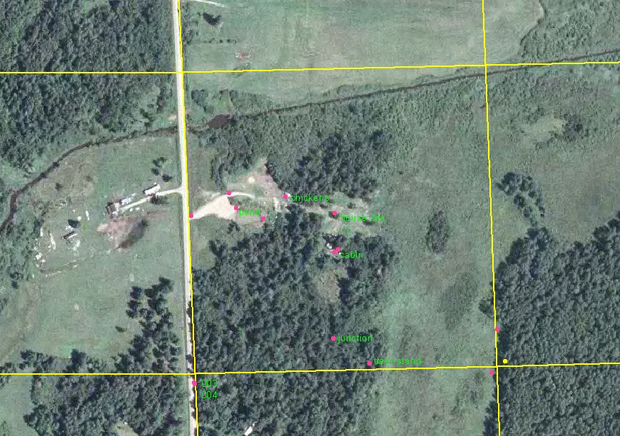
(Click on the photo for a larger image; then you can read some of the labels!)
The above picture shows the 40 acres (or 40 square acres, as Pablo would call it) that I call home. The yellow lines are the property lines. Sand Creek is the very very straight line cutting diagonally across the northern end of the property; the stream was ditched in 1918 when people optimistically believed that fertile soil abounded in the logged-off land and extensive bogs to the north. One of my goals is to restore a few curves to this section to improve the carrying capacity for brook trout.
The eastern third of the land, light green in color, is all low sedge/alder/willow swamp. During dry summers we may be able to walk across it without getting our feet too wet, but usually hip boots are a requirement. The land across the swamp is all county tax forfeited land, 40 acres, hopefully too small for the county to bother logging the mature aspens there.
The southwest quarter of the land, dark green in color, is the white pine woods. The pines are of varying height and maturity; the largest ones are near the middle of the property. The lighter colored shape in the woods is a small bog; the cabin is just to the north of the bog, and the new house site is about 50 yards north of that. My gardens are between the new house site and the swamp to the east. The patch of trees between the new house site and the creek is mostly tamarack.
Following the driveway from the house site towards the road, we pass the chicken coop and yard on the north side of the road, and the horse pasture beyond that. The pond does not show up well in this photo, but I have labeled the location. The light colored area between the pond and the road is bare sand and gravel; this photo was taken in 2003, not too long after the pond was excavated and the sand and gravel used to build up the driveway.
Contrast the photo above with this one, enhanced from a 1939 aerial photo:
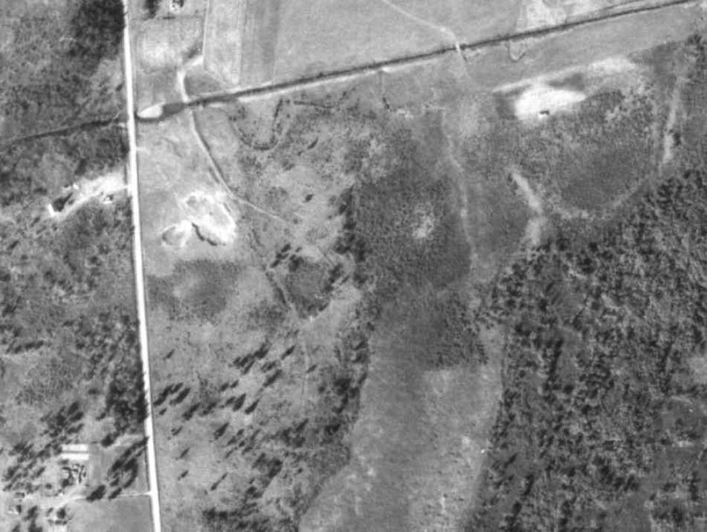
Our 40 was part of the farm across the creek back then, and used mostly for pasture and for the gravel pit where the pond is now. The farmer, a Swedish immigrant, quit farming three years after this photo was taken, and to my knowledge this 40 was not used as pasture after that. This picture shows the grade of the old Fleming Logging Railroad, which was in existence in the 1890's. The main line crosses the creek near the road; a siding branches off from the main line near what is now our chicken yard, and rejoins the main line across the bog from our cabin. The grades are still visible today; the siding is kept clear as a trail.
I am amazed at how sparse the trees are in this photo. The land must have seemed much more open back in those days.
Edited to add: I should say that the land relief around here is pretty flat. I doubt if there is more than twenty feet of difference between the highest point and the lowest point here.
More history to follow soon!
9 comments:
That's pretty neat to have a visual history of the land you live on. I'm surprised by the difference in the trees, too; I guess we always think of "the past" being more heavily forested, waiting for clearing. Or perhaps not waiting for clearing...
Unfortunately I don't have a photo of what this land looked like before the virgin white pines were logged in the 1880's-1890's; I have seen photos in the local history books of log sleds loaded with three foot diameter white pine logs. The past, as shown here, is clearly the past after the damage was done!
Sigurd Olson once said that at the time that the Europeans came to this country a squirrel could travel from the east coast to the mississippi river without ever touching the ground. I have seen those photos of the 3' diameter white pines also. I would love to see what Northern Minnesota must have looked like 200 years ago.
Thank you for an interesting post. It was nice taking an imaginary walk on your property.
deb, very interesting, very cool.
it's interesting about the forestation thing. just the other day i was having a bit of fun on the minnesota historical society's image archive search
http://collections.mnhs.org/visualresources/
you can search for all kinds of cool old photos.
what was interesting was that everywhere i looked up that i've been to around stillwater, in the st. croix valley, there are many, many more trees there today than when the pictures were taken (which was during and after the lumber days). and katie and i agreed that we definitely think of the world as less-forested today than in those days, but i don't think that's always so true.
anyway, i already did a search for "sand creek" on that site and didn't have any luck, sorry! :)
again, thanks for an interesting post.
I agree with the DBum that this is a cool idea, one we could all steal. The USA's second and third growth forests are pretty extensive and some areas like New England are more forested now than 100 years ago. The problem in a lot of managed forests is the loss of diversity compared to the original.
Can you recurve that creek without jumping through a zillion EPA type government hoops?
Terry-I'm a big Sigurd Olson fan myself. One year when my husband and I were still dating, we bought each other, without any prior knowledge, copies of "Listening Point". Glad you liked the post, and it's nice to see you here commenting.
dharma bum- I've looked at that database a couple of times--cool stuff! You can probably find the photos of large loads of white pine logs that I mentioned there. One thing I found not too long ago--actually I was trying to research when the DNR started stocking stream trout--was an article from Minnesota History magazine, published by the MHS, about the history of carp in Minnesota. They actually told a lot about the early fish hatcheries, and trout stocking. I was trying to find out if it was possible that Sand Creek was stocked before the 1900's. I think it probably was not.
FC-fortunately, I work with most of the people I would have to get permits from, so that part would not be much trouble. The only problem would be that Sand Creek is still designated a county ditch, and there's a lot of red tape and stupid county commisioners involved with dropping that designation!
What an excellent post! I love maps and such. This really gives me a nice sense of your holding. I can see why there would be so many foxes on your property!!!
I agree with the wise Cracker's comment. I wondered about the various agencies that have dominion over the creek. If you did give it some meanders or such, would it become a designated wetland or something like that which would restrict your use/control of it? Just curious.
pablo-actually I was thinking of your many great descriptive posts about Roundrock and Fallen Timbers as I was writing this.
Creating more meanders would not change any status that the creek does not already have; it is a designated trout stream already. Unfortunately it seems that the designated trout stream status hasn't prevented a few other trout streams in the area from being destroyed by illegal activities.
It's so great that you have access to such an early aerial photo. I suppose that back then - as it was on our land- that the trees were strictly utlitarian, and clearing them for lumber and land meant not only progress but personal wealth and achievement; the land was mostly cleared to be arable for 'profitable' crops, they hoped anyway.
Post a Comment